

When Is the Best Time
The hike to Alamere Falls, north of San Francisco in Point Reyes National Seashore, is one of the most unique in the country, taking you through thick forests, lakeside meadows, and ocean shoreline to a mossy “tidefall,” or waterfall flowing into the ocean.
There are only three tidefalls in the United States, of which two are in California. Located in the Coast Miwok village of Bauli-n (now Bolinas), Alamere Falls is one of the most impressive hikes in the country.
Best Time of Day to Hike Alamere Falls

The best time of day to hike to Alamere Falls is in the morning. There are three reasons why:
- Hikers typically fill up the Palomarin Trailhead parking lot before 8:00 a.m., occasionally prompting a parking lot closure.
- Much of the trail is exposed, so it is more comfortable to begin hiking before the heat of the day.
- It may take three hours to hike to Wildcat Beach. Low tides are typically around midday when it’s easier to hike down the beach.
Ultimately, it is dangerous to walk during high tide, so before your trip, review Surfline to determine the times for low tides.
Tip: To benefit from the great advantages of being there early without having to get up at 5 or 6 AM, spend one night nearby! There is an excellent new and unique place where you can stay: Smiley’s Saloon & Hotel (via booking.com with a low-price guarantee). It’s an easy and quick 13 minutes drive (Google Maps) to the trailhead!
If you stay in SF, check the booking.com deals and bookmark the results to save money: San Francisco Hotel Deals
Best Time to Hike Alamere Falls | Months

The best time to hike Alamere Falls is April, May, June, and October when temperatures average 50° to 60° Fahrenheit (13° to 16° Celsius). There is little to no rain in these months; two inches at most in April.
You’ll likely encounter a cool, damp marine fog called “June Gloom,” which may cover the sky in early summer, but this is fortunate since the trail is so exposed to the sunshine otherwise.
Swimming at Alamere Falls
There is no official swimming spot on the Alamere Falls trail, but many hikers enjoy swimming at Bass Lake, about 3 miles from the Palomarin Trailhead. However, access is not easy and there are no lifeguards near this lake. It is also dangerous to swim in the ocean because this is a common place for shark encounters and there may be hidden currents.
Weather at Alamere Falls | Seasonal Guide

The Pacific Ocean influences the weather at Alamere Falls: While summers are hot and winter months cold and wet, the climate is never extreme. The most pleasant temperatures can be experienced in spring and fall.
Summer: June through September
Summer starts later in Alamere Falls: June, July, August, and September are the driest, hottest months of the year, with temperatures as high as 88° (31°) degrees. During these months, you’ll need to wear a hat, sunscreen, and light, loose clothing.
In the early summer, you may experience fog, but this often disappears by midday. The trail is exposed and will be very warm.
Fall: October through December
Fall temperatures in Alamere Falls begin to drop, with temperatures as low as 48° (9°) degrees in December. In fall months, storms increase, raining up to 9 days per month by December.
Storms also bring strong winds in November and December. During these months, you’ll need to wear layers of long-sleeved shirts, sweaters, windbreakers, and waterproof clothing. The trail may become muddy, so it is prudent to bring hiking boots with good tread.
Winter: January through March
Winter months in Alamere Falls are the coldest, wettest months of the year, with temperatures consistently as low as 48° (9°) degrees. Storms are common in the winter, with heavy rain for several days each month.
During these months, you should wear layers of sweaters, jackets, and windproof, waterproof clothing. Bring mud boots or hiking boots with good tread.
Spring: April through May
Spring in Alamere Falls is fresh and warm, with temperatures rising as high as 24° (75°) degrees. Spring can be cool, windy, and foggy, so you should bring layers of short- and long-sleeved shirts and sun-protective clothing.
There are multiple trails to Alamere Falls (NPS information), but the shortest and easiest trail starts at the Palomarin Trailhead parking lot (Google Maps). This article covers the trail via Wildcat Campground and Wildcat Beach, starting from Palomarin.
Trail Length and Difficulty

The hike is about 10 to 12 miles long (16 to 19 kilometers), depending on the route you take. It is considered a “moderate” trail in terms of difficulty on AllTrails, due to the distance and elevation gain. The shortest hike starts from the Palomarin Trailhead. Here is a link to the AllTrails hike profile.
Hiking Time

Most hikers starting from the Palomarin Trailhead will complete the trail in 4 to 8 hours, depending on their walking speed. When I hiked it, our group averaged an easy 2.5 miles per hour (4 kilometers per hour) and completed it in under 6 hours, including a leisurely lunch on the beach.
Getting to Alamere Falls

If you want a parking spot on weekends or in the summer, it’s best to arrive at Palomarin by 7:30 a.m., which means you’ll need to leave San Francisco by 6:00 a.m. (it’s a 1- to 1.5-hour drive). If you’re departing from the South Bay, you’ll need up to 2.5 hours of driving time, which means a 5:00 a.m. departure to secure a parking spot. And if you’re visiting the Bay Area and plan to go on this hike, stay for at least two nights in or near San Francisco.
Trail Maps

You can print this official National Park Service (NPS) map. You can also download an offline map for free through the NPS smartphone application or for a subscription fee through the AllTrails application.
Trail Description | Palomarin Trailhead

You’ll start on the Coast Trail from Palomarin Trailhead, gradually rising around 300 feet in elevation (90 meters) over the first mile and a half (over two kilometers). This first hour includes cliffside views over the ocean followed by a trek through a fern-lined forest. The path is smooth and compact, easy to walk on. If it has rained recently, the ground may be muddy.
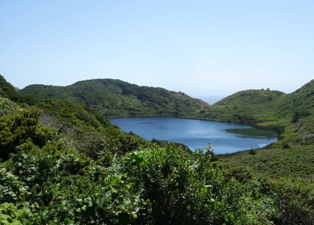
After you’ve reached the forest, the path drops around 300 feet in elevation (90 meters) as you walk towards Wildcat Campground. In this section, you’ll hike through a calm, dappled forest past ponds and lakes.
After approximately 4 miles or 6.4 kilometers, you’ll reach the turn-off point for the unofficial shortcut to the falls. The shortcut trail is marked by a stick in the ground. In May 2021, this stick was easy to see as it was draped in discarded face masks. However, NPS does not recommend this trail, which includes technical scrambling down rocks near the waterfall. As a result, NPS does not include this shortcut trail on its map.
Instead, continue to the right towards Wildcat Beach, rising slightly then dropping to sea level as you approach Wildcat Campground. This trail section has tall grass, so you’ll need to check for ticks later.
Once you’ve reached the campground, you may want to take a bathroom break and survey the ocean for large waves. If there are tall waves or the tide is too high, do not continue hiking. Every year, NPS rescues people from this hike because the beach is the most hazardous part of the hike. If the water is too dangerous, return to hike this trail another day.
If it is safe to do so, you’ll walk along the ocean for a mile until you reach the falls. There, you can take photos and relax. You’ve arrived!
From the falls, you can return the same route or take the shortcut back to Palomarin. However, if you take the shortcut, you will have to scramble up loose rocks and steep hills for half a mile, often pulling yourself up with a rope. The safest way is to return the way you came.
Costs and Parking

The Palomarin Trailhead parking lot is free, but on your return trip from Alamere Falls, you’ll need to pay up to $10 for a toll fee to drive south into San Francisco over the Golden Gate Bridge.
San Francisco Tips
If you’re staying in San Francisco, choose at least one of the above tours: Golden Gate, Hop-On – Hop-Off, Muir Woods, and Wine Country Tour. You’ll love it. It’s very comfortable, as you can use a mobile or printed voucher.
San Francisco Hotel Deals: Check the following deals and bookmark the results to save money (in case you don’t book now): San Francisco Low Price Hotel Deals (via booking.com)
Day Trip Locations Near Alamere Falls

If you’re traveling to Alamere Falls for the day, you may wish to stop by, or extend your stay in, one of these locations:
- Stinson Beach, a small beachside city 20 minutes from the Palomarin Trailhead, where you can visit the Stinson Beach Market for a sandwich, groceries, or coffee. You can also enjoy its white sand beach, though we don’t recommend swimming there (due to the presence of sharks). There are
- Mt Tamalpais (nicknamed “Mt. Tam”) is a well-liked mountain in San Francisco to hike due to its excellent views of the Golden Gate Bridge. Several challenging hikes, such as the Steep Ravine Trail, are located only a 30-minute drive from the Palomarin Trailhead.
- Sausalito, located in the “Marin Headlands,” overlooks the Golden Gate Bridge and San Francisco. For a quirky experience, you can rent a houseboat in the marina. Sausalito is a 1-hour drive from the Palomarin Trailhead.